 |
 |
 |
 |
The History of Winterton
RURAL GEOGRAPHY 2000
A SETTLEMENT STUDY OF WINTERTON
Submitted by: Lois Carew
Transcriberís Notes:
The original student paper was stored at the MUN Maritime History Archive. It was scanned and formatted into Microsoft Word in February 2002 by William Tucker, grandson of Ellis Tucker. Explanatory notes appearing inside square brackets were added to correct some erroneous information. The corrected information was provided by William Tucker and Charles Tucker (son of Ellis).
The following maps have been omitted to keep file size to a minimum for transmission over the internet:
Map 1 - Hand-drawn map of the Avalon Peninsula showing location of Winterton
Map 2 - Topographical map showing exact location of Winterton
Map 7 - Fishing Berths in Winterton and other information
ACKNOWLEDGEMENT
I would like to greatfully acknowledge valuable assistance given to me by Dr. Otto Tucker, Mrs. Marie Budgell and Mrs. S. J. Carew
SETTLEMENT STUDY OF WINTERTON
Introduction
This essay describes the location and form of the settlement, Winterton, and then analyses the process of settling, with particular reference to the land inheritance pattern of the Tucker family, one of the early families to settle in the community. It also examines how the particular settlement pattern originated and why it occurred in that manner The agricultural land use and morphology is studied but particular emphasis is given to the fishery. This formed the basis of the economy of the community rather than farming due to the fact that available land was limited because of marshy, rocky soil and a harsh climate. The present situation of Winterton is also examined.
Winterton was formerly called Scilly Cove, the name is believed to have been adopted from the Scilly Isles, off the Southwest coast of England. The name was officially changed to Winterton on August 13, 1912 in honour of Sir James Winter, Premier of Newfoundland from 1898 to 1900. Winterton is located on the east side of Trinity Bay, on the Avalon Peninsula, ninety miles from St. John's by highway. The settlement has a safe harbour, which often provided shelter for schooners engaged in the fishery.
I would classify this settlement by the term Demongeon uses, Intercalaire, because it incorporates some traditions of dispersed settlement and some of agglomerated settlement. The location of a single house on a single unit of land is dominant, however, the distance between the houses was irregular and short. It is believed that the settlement was first dispersed with large distances between the houses then as the population grew houses were placed closer together. This also allowed for stronger social cohesion, as the people were gathered in pursuit of a common livelihood, fishing. As in Atlantic Europe before 1700, there was a haphazard form of property layout, which is mainly a product of subdivision of the land among male heirs. The houses followed the topography, being mainly located in the valley, possibly for protection but mainly because it was here the best soil was found and the houses could be close to the shore for fishing. As the settlement grew the houses were built on the hillsides. The irregular and small plots of land are expressions of the simple traditional technology used for cultivating the land such as spades, shovels and pick axes, for rooting stones. The size of the plots was also a product of the poor soil. Excessively rocky or marshy soil was not generally enclosed.
Settlement History
The earliest record of the settlement was made in 1675 by the secretary of Admiral Sir John Berry, who was dispatched by the Colonial Office in England to investigate illegal settlement in Newfoundland and if possible to deport the settlers to England. The investigation area extended from Bay Bulls to Cape Bonavista including Scilly Cove. Here he discovered three planters, John Peeten, who was married, and had six children and employed twenty-one men servants; James Weeksell, who had two boats and ten men servants and Richard Hopkins, who also had two boats and nine servants. Admiral Berry said it was too many to deport and just made a census record. Each planter had one stage and when the French raided the shore in January 1697 they found a great quantity of fish and cattle at Scilly Cove.
These early planters received their supplies, hired servants and sent their fish back to England to be sold. The ethnic origin of the community is believed to be English. In 1675 there were four ships arriving at Scilly Cove, the "Katherine" and the "Providence" from Hampton, England and from Weymouth, England the "Dorothy" and the "Sarah". Together they brought a little over one hundred and thirty men from whom the planters could hire the necessary crew to prosecute the fishery.
Included in the families who settled permanently in the community were the Tuckers, the Clarkes, the Brantons and the Pinhorns.
Genealogy and Land Ownership
First Generation
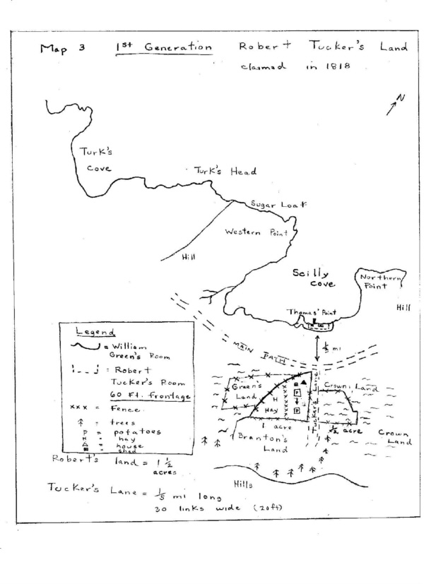
Robert Tucker, who was born near Poole, England in 1800 and died in 1874 was the forefather of the family. [Ellis Tucker in his "Journal" states that he died at age 94]. He belonged to the Church of England. He arrived in Scilly Cove in 1818 having run away from home to become a fisherman in the "new land". Both he and his father were formerly coopers. He married Mary Green from Dorset, England, who was the daughter of the skipper, William Green, on whose boat he had stowed away.
Robert acquired through his wife (as a dowry), sixty foot frontage along the shore of the Cove, near Thomas' Point (see map 3). This was part of William Green's "Room" (a Dorset expression for the property near the waterfront).
Robert did not inherit William Green's stage or flake but built his own. The main path through the community ran one third of a mile from the shore. Robert cut a small lane from the main path, thirty links wide extending one fifth of a mile south to the interior forest and hills. This became known as Tucker's Lane. He cleared two parcels of land on either side of the lane. His house was located seven feet from the lane and five feet from the main road (see map 3). The location of his house here, rather than closer to the shore could possibly have been for protection and also because the land was more fertile for gardening. Another reason might have been that it was close to a forest area, a natural supply of timber.
It is believed that some of the earlier settlers of Scilly Cove had two houses, one located relatively near the shore, used during the fishing season, and one further inland. Many of the ponds behind the settlement are called after early families - Clarke's Pond and Pinhorn's Pond. This interior house was used during the winter months, called a "tilt". This was a sod and log house and was located in the heartland of the forest where the logging and sawing of wood by a pitsaw was carried out to be built into houses, boats, stages, wharves and flakes. Robert Tucker was not known to have two dwellings.
Second Generation
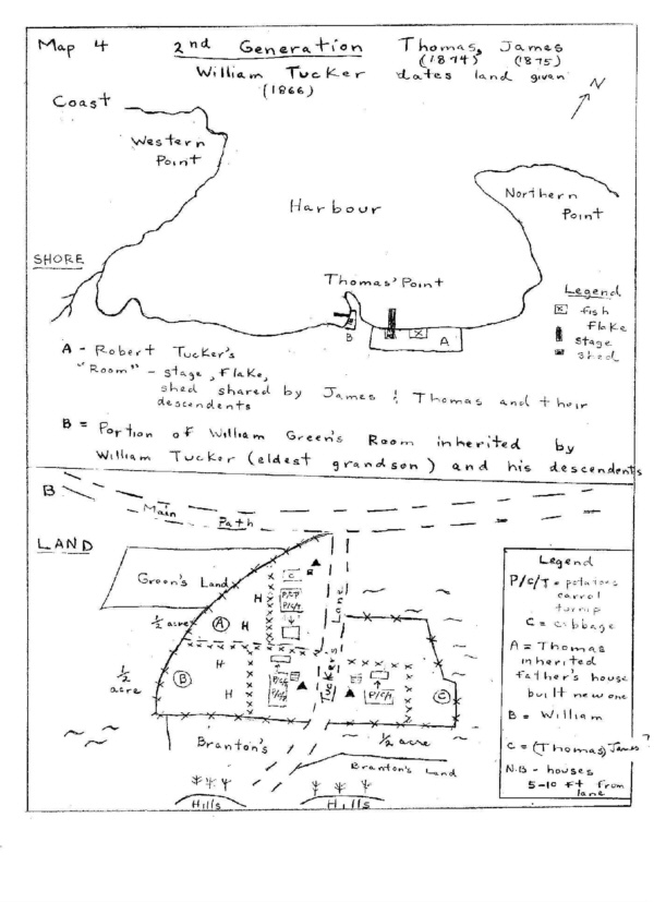
Robert's three sons, William, James and Thomas all received a portion of their father's land. William and James were given land (in 1866 and 1875 respectively) when they married. Thomas inherited land in 1874 when Robert Tucker died. They each erected a fence to separate their land.
FENCES: It is interesting to note that in Winterton three major types of fences were used. One type was a larger fence called a "laer" fence or "wriggle rod" fence. This consisted of three rails of slender small green fir saplings fastened to two posts at regular intervals around the garden. The second type of fence was the picket fence of larger fir or spruce saplings secured to posts with nails. The third type was the pailing fence made from sawn wood slabs.
James and Thomas and their descendants shared Robert Tucker's "Room" but each had their own boat. William Tucker inherited a portion of William Green's "Room" since he was the eldest grandson (see map 4). Thomas, who was the middle son inherited the house in 1874 because he had cared for his father until he died. He tore down the house and built a new one in the same spot.
None of the sons left the community because the fish was plentiful. In 1857, 4930 quintals of cod fish were cured.
Third Generation
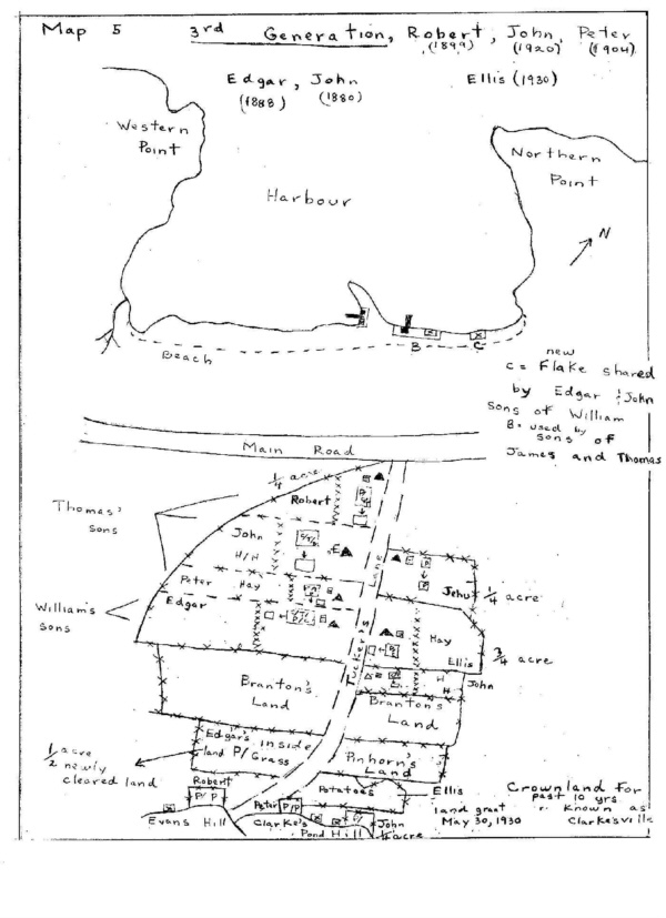
In the third generation two of the daughters, Eliza Jane of Thomas and Minnie of James were the first to move to the United States (Boston) to work as servant girls. Minnie returned each summer to visit Newfoundland. James' son, Noah, also moved to the United States to seek employment as a carpenter. Thomas' land was divided equally among his three sons. Robert, Peter and John each received land when they married (see map 5). Peter, the middle son, inherited the house because he looked after his father. William's land was given to Edgar, the younger son, who also inherited the house after his father died in 1888. John enclosed his own land in 1880 adjoining Ellis'. Both sons, Edgar and John, built a new stage and flake and shared it. They also borrowed nets, boats, and hooks.
James' house was inherited by his grandson, Ellis (Jehu's son) who was raised as James' youngest son. Jehu married Caroline Reed in 1898 [in actual fact his wife was Sarah Ann Harnum who he married in 1900] and they had one son, Ellis. When Caroline [Sarah] died in 1905 [actually 1903], Ellis moved in with his grandfather, James, who looked after him.
When James died in 1930, he left his house to Ellis. Jehu had previously enclosed an acre of his father's land and had a house built. He decided to move to the United States in search of work and left his house to his foster son, Roy. [It was Noah who moved to the United States. The house was referred to as "Uncle Noahís house"]. Ellis Tucker was the only one of the family who received a land grant (May 30, 1930) for 2 acres and 22 perches perches [Ellis records it as 3 acres and 22 perches]of land at the foot of Clarke's Pond Hill, bordering on the road to the Church of England cemetery [?].
Fourth Generation
In the fourth generation, the families of Robert and John were large. Characteristic of this generation is also a large scale movement to the United States.
Migratory Patterns
Many of the young girls in the community moved first to St. John's to work as servant girls and then often, after reading an advertisement in the paper, decided to move to the United States, frequently Boston. There was a close connection between Boston and Newfoundland dating back to the 1700's when there was a fish trade between the two places. Gloucester fishing schooners came to Scilly Cove to recruit crews. Often favourable reports and money would be sent back by early migrants enabling others in the community to go. The exodus of young people during the early 1900's from Winterton was a common occurrence. Some men moved to Brooklyn, New York and to the New England States as construction workers where jobs were easily acquired Peter and John Tucker went as seasonal workers (carpenters) . During the First World War many young men from Winterton enlisted in the Royal Navy. Then during the depression (1928 in Newfoundland) , some young men and women moved to the United States in search of employment. For some men disliking fishing this was an excuse to leave. Others, like Frank and Alexander Tucker who were living in the States, returned to the community during the depression feeling that here the cost of living was less.
During the Second World War, it was easy to secure employment in other parts of Newfoundland - in Corner Brook and Grand Falls as loggers, in Buchans as a miner and as a worker on the American bases in Argentia and Pepperrell. Most of the men who did not go overseas found work in these places and settled there. Ellis Tucker tore down his house and moved to Markland in 1955 [actually he settled in the Haricot Land Settlement in 1935 after working for about 4 months in Markland. His house in Winterton was taken down some time later. He used the lumber from it to build a new house in Whitbourne in 1947. He lived in Whitbourne until the death of his wife in 1981 after which he lived in Clarenville and St. Johnís until his death in 1986]. The Newfoundland Government set up a commission for agricultural settlement, paying people to move there. The project failed partly because many of the men moved to the American bases to work as carpenters during the war years.
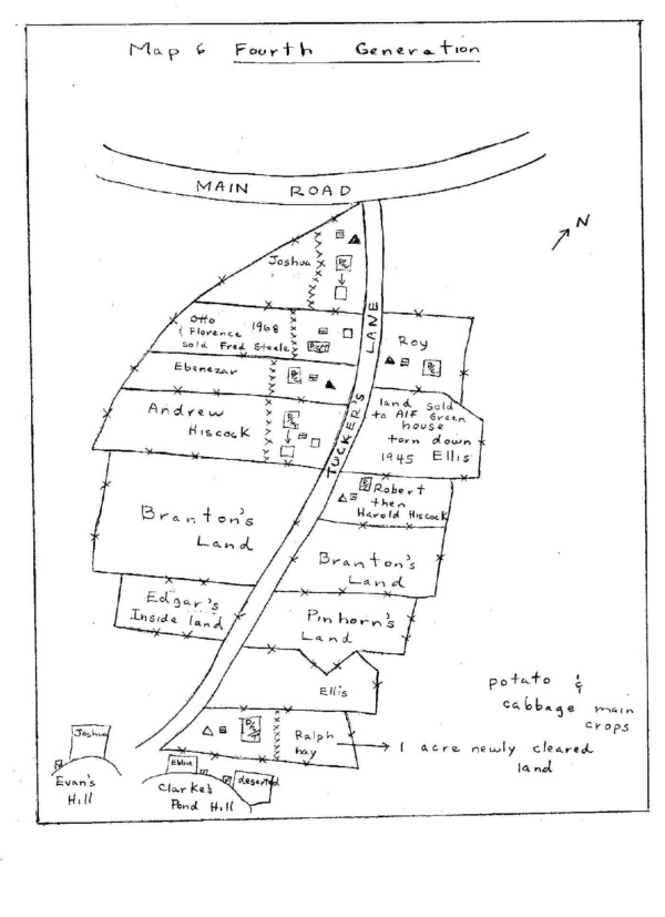
John Tucker's house was inherited by Frank, his youngest son, in 1938. Frank moved to the United States in search of employment. Frank only returned one year during the depression. When leaving he left the house to his brother, Robert who had moved to St. John's and used the house as a summer cottage. Robert then moved to the States and left the house to a cousin, Harold Hiscock who now uses it as a summer cottage. It is not known whether the house was sold or given to Harold.
Edgar Tucker's house was passed on to Andrew Hiscock who was not a relative. This was the first time land was passed out of the family. Edgar's only son, Alexander, moved to the United States in search of employment and Edgar advertised in the community for a young couple to stay with him. This was a common practice in the community with the understanding that the young man would inherit the house and land from the elderly man.
Robert Tucker's land was given to Joshua (see map 6), the youngest, who also inherited the house in 1954, since he had looked after his father. He tore it down in 1955, because it was in need of repair, and built a new one on the same spot.
Peter Tucker's land was divided between Ebenezar and Thomas. Ebenezar, the younger son inherited the house in 1947 which he renovated by converting it into a bungalow. It is still existing in Winterton. John Tucker died without having a will. His house was sold to Fred Steel for $700 in 1968 with no deed of transaction. The money was divided between Otto and Florence Tucker. This is not a case of direct female inheritance but it is interesting to note that a female does receive a part of the value of the ancestral house.
Summary
The pattern of inheritance in the Tucker family, as in the community was patrilineal. Evidence is seen in the place names such as Green's Hill, Parrott's Hill, Andrew's Hill, Tucker's Lane and Hiscockís Lane. There was a general pattern of Endogamous marriage for the male line in the Tucker family. One reason for this marriage pattern could be due to poor transportation, mainly by sea, which resulted in relative isolation of the community. The females are seen to move away and marry. There was no set rule as to which son should inherit the house. It was often the youngest son but always the son who cared for the father. No woman inherited land. This was the continuation of the English tradition. Also it was due to the fact that men create wealth by fishing and therefore should inherit. The subdivision of land was partible. It was subdivided equally among several male heirs. This is also dominant in Ireland, Scotland, Norway and most of Atlantic Europe. The social organization was the extended family or kin group. This was dominant in Central and Eastern Europe up to 1850. Like the hamlet settlements, society was egalitarian (equal shares of land to sons) and arranged on an informal basis. The family was the unit of economic production.
Resource Utilization
A. Land Use
First Generation
Robert Tucker cleared the two acres of his land upon which his house was located by using an axe to cut down the trees and a pick axe and shovel to remove large stones. The only crop grown was the potato which was grown in long narrow rows called "drills" in two small patches of land near his house. These patches shifted from year to year but there was no intentional system of rotation. Some years no potatoes would be grown. The remainder of the land was used for hay. The crops were not individually enclosed but there was a small fence separating the hay land from the potatoes. The number of bushels of potatoes grown annually per household was twenty-one. There were no other root crops or grain crops grown. The number of tons of hay per family was 0.06. Robert Tucker had a cow which grazed in common land or in the "meder". For a short period, while the root crops were still in the ground the cow was allowed to graze in the hay land on Robert Tucker's property to eat the stubble and help cut the grass. This was the reason for erecting a fence within his land.
Second Generation
In the second generation the acres of Robert Tucker's land were cleared by his sons using the same tools their father used. The clearing was not formally executed but done spastically in the spring. The sods were chopped out with an axe and shovel, a plow was never used. The unit of land cleared varied from family to family. People viewed land as a source of supplementary food supply It was also regarded as a status symbol - a person who grew no vegetables was not regarded highly among other members of the community. Land was also used to graze domesticated animals but this land was usually not fenced and was Crown Land used as a common pasture. In this generation no additional land was fenced because the amount of land each son inherited was considered sufficient to grow the number of crops which they needed.
Thomas, William and James worked their land separately and did not share the produce. Robert and James did share their father's flake and stage, boat, nets and hooks.
One fourth of each of the son's land was used for growing vegetables - carrot, turnip, parsnip, cabbage and mainly potato. The remainder of land was hay land. In 1857 there were 5.61 (6) barrels of potatoes and 0.20 tons of hay per household. In this generation there was more intensive use of the land. The amount of crops grown was generally enough to feed a family. It was a subsistence arable economy for several reasons. The soil was swampy and rocky and hard to till and it was therefore considered better just to produce for yourself. Also the women tended the garden in their "spare" time and there was no market demand for the crops and therefore no external stimulus or pressure. Each family had two goats, one sheep and Thomas and James had a cow. In 1857 there were fifty-six cows, ten sheep and 96 goats in the community. The sheep and goats were set loose to graze around the hills. There was no formal pattern of transhumance but the animals were allowed to wander through the spring and summer. In the autumn there was a roundup and the animals would be either killed or kept in sheds (located near their houses) for the winter. Cows were valued more highly and therefore better care was taken of them. They were allowed to graze on public land and then kept in sheds and fed hay grown in the gardens. The tools used to cut the hay were scythes, sickles and smaller reap hooks.
Third Generation
In the third generation, Jehu Tucker did enclose part of his father's land when he married his first wife, Caroline Reed in 1898 [actually Sarah Ann Harnum in 1900]. Edgar Tucker enclosed an inside acre of land exclusively for potatoes and hay. All the sons grew a few alternating rows of vegetables, turnips, cabbage (limited to marshy land) and roughly five to ten barrels annually of potatoes on small sections of the land on which their houses were located. In 1910 there were 7 barrels of potatoes, 184 cabbage heads and one barrel of turnips per family. Robert, Peter and John, sons of Thomas, did also enclose small potato gardens known as "inside gardens" located at the interior of the settlement at the foot of Evan's Hill and Clarke's Pond Hill. This was a common practice. Taking the distance factor into the location analysis of these interior plots of land they were not ideally situated. However considering the fact that the hills were excellent natural storage sheds for potatoes, the location of the land at the interior foothills is more clearly understood. These root cellars had a strong wooden door leading into a cave lined with wooden boards. It was insulated from frost. Some families in the community did not have gardens adjoining their property but only had "inside gardens".
Each family had two sheep, four to ten hens and two goats and two cows. The male goat was used as a beast of burden in the winter harnessed to a sled to pull firewood. The female goat was used for supplying milk.
In 1911 there were thirty-seven cows and thirteen horned cattle, seventy-four goats, one hundred and ninety sheep and five hundred and fifty-five poultry.
There was a custom of sharing slaughtered animals with relatives and friends. Occasionally sheep were sold to one of two local stores in 1900 owned by Miss Caroline Sansom and Miss Harriett Parrott. The four main products generally purchased were salt beef, molasses, tea and flour.
Fourth Generation
In the fourth generation no new land was enclosed, partly because land was not valued as highly due to the large out-migration of young men and women. In 1935 there was only one acre of land in the settlement for turnips, 15 acres for potatoes, 5 acres for cabbage and 20 for pasture, 45 acres in hay. There were 24 bushels of potatoes grown per family and 0.6 or approximately one barrel of turnip, 319 lbs of cabbage. Members of the community also grew berries that could be jammed. In 1935 there were 36 gallons of cherries and plums, 18 gallons of strawberries and 71 of currants and gooseberries. There were fewer vegetables grown in this generation due to the creation of other types of jobs after the War. Peter Tucker [actually Thomas, son of Peter] became a truck driver and Robert Tucker became a general labourer and Otto Tucker became a professor. Some men moved from the community permanently. Others like John Tucker went to Brooklyn as a seasonal worker.
Each Tucker family had two to six sheep which were raised mainly for wool, also for food, two to four goats and had a horse which was harnessed to a sled and used for pulling wood.
Fertilization
The fertilizing of the land began in the spring with the placing of stable manure and poultry manure over the crop land. Sometimes fish offal and kelp were also used. The potatoes and root vegetables were then planted (often by the women) in long narrow trenches and covered with shovelfuls of soil. During the caplin season, caplin was spread on the potato seeds and covered to help fertilize the soil.
Division of Farm Labour
There was a division of field tasks to both men and women of the community. The men provided fire wood, built houses, boats, fences, furniture and helped dig vegetable gardens. They also snared rabbits and shot sea birds and seals. The women cared for the livestock, planted and tended the vegetables, and carried fresh water supplies for the house, carded wool, knitted mitts, socks and sweaters and hooked mats from cloth scraps.
Summary
Each family in the community had a private plot of land which they fenced to prevent wandering animals from destroying their crops. Today with the decline in the number of livestock kept, there is also a decline in the number of fences surrounding .houses. This private plot of land or kitchen garden in Scandinavia was called a Gort. The settlement was characterized by a high degree of self-sufficiency - each family own their own house and land which was tax free. Society was organized at an elementary level with little specialization of labour. The majority of men were engaged in primary production. Like part of Ireland, the settlement was characterized by small holdings of land, poor soil with the main crop grown the potato.
B. Fishing
The origins of the settlement of Winterton can be traced back to the efforts of the settlers to exploit the main primary resource - codfish. The fishing season lasted from May to late October or early November. The earliest settlers fished near the shore from rodneys using a hook and line method. This was time consuming but usually brought good results. In 1677 the catch of fish amounted to seven hundred and eighty quintals. The amount and value of fish varied from year to year. In 1911 the total. value of fish products was $47,005 and in 1921 was $44,535. The average cod price per quintal fluctuated. In 1926 it was $6.50. In 1932 it was $4.00. In 1935, the catch of fish was only valued at $14,444 - a very bad year.
Three Main Types of Fishing
Three main types of fishing ñ jigging, trap fishing and trawl or "bull tough" fishing can be traced through the first three generations of the Tucker Family. Robert Tucker jigged for cod, alone in a boat under 15 quintals close to shore. The water depth for the jiggers was 30 - 40 fathoms. There were annually fifteen to twenty fishing in this manner with little expense. In 1836 there were 46 dwelling houses with 58 boats under 15 quintals and three from 15 - 30 quintals.
William Tucker is thought to have owned one of the first cod traps in Winterton. The water depth for the trap was 50 - 70 fathoms. His berth was located one mile from Turk's Head (see map 7). The berths were not drawn for but were claimed for one year by the first person to put a net (usually a salmon net) in a particular berth in the spring. When this net was taken up the trap was immediately placed in the spot. Today the berths are drawn for each spring.
In 1911 there were ten cod traps in the community. These traps were owned by families as four or five men were needed to haul and set a trap. If there were not enough men in a family to handle a trap, other men from the community were hired as sharemen. The total catch was divided into shares, one for each member of the crew and one for the trap. This share was used by the owner to pay for repairs for the trap, as well as expenses involved in operations.
The third Tucker generation engaged mainly in trawl fishing which used larger boats which were first equipped with sails. In the 1920's engines were introduced to allow the fishing to be done further off shore. The water depth for trawls was 60 - 70 fathoms. The usual fishing crew consisted of a father and his sons or else two or three brothers. These fishermen were on the fishing grounds before daylight to set their trawls and haul them again before they returned home in the afternoon. The bait used was mainly caplin, herring and squid. The anchor used for the trawls was called a "killick" or "mooring stone". It consisted of a large wood cross beam and three thinner strips of woods enclosing a large stone in the centre. The main species of fish caught was cod. However, in 1857 there were six quintals of salmon caught and cured.
Besides those fishing at home, there were men in the community including James, William and Thomas Tucker who were employed in the Labrador fishery. Some went to Greenland, Labrador during the summer to fish as "servants" on wages for Job Brothers. Others went to Bonne Espenence or "down on Bony" as servants with Capt. George Whiteley. These men were usually advanced wages to outfit themselves before they left for Labrador on schooners. In the period 1891 - 1901 there were fifty-seven men engaged in the Labrador fishery and twelve men in 1911. Some of these men also worked on the two schooners taking part in the fishery each year from Winterton. These schooners were both eighty-four tons and in 1891 their total catch was 1,111 quintals while in 1911 the last year that they were recorded in the census returns, their total catch was only 300 quintals. These schooners also took part in the Bank fishery with catches of 779 quintals in 1891 and 400 quintals in 1901.
Another important part of the Winterton fishery was the fishing done at Baccalieu Island. There were two types of fishermen taking part in this fishery; those who took their boats and equipment to Baccalieu, fishing and living there for the entire season, curing their fish and bringing it home in the fall for shipment. Then there were those fishermen who owned larger boats of more than thirty quintals who went to Baccalieu and brought their fish home for curing after they had caught a load. The women of the community cured the fish while the fishermen returned to catch another load.
Division of Labour in the Fishery
The various tasks associated with the fishery were delegated to both males and females. The men and boys built boats and fish flakes, wharves, prepared and mended nets and fish lines. They caught the fish and split it and often salted it.
The women then took over. When the fish was taken out of the salt the women thoroughly cleaned it leaving no blood spots which would lower the quality of the fish. After washing it was taken to flakes where it was spread out evenly on boughs to dry. Each morning the fish was spread out, then at night taken up in piles and covered with "rinds", (the bark from tree trunks taken in a strip) . When it was dry enough the fish was taken usually by wheelbarrow to the merchant's premises for sale. The fish was usually graded top grade maderia, considered the best in Trinity Bay.
The Fish Products Sold
In-the late 1890's, turbot and herring were caught, pickled and packed in barrels for export. At this time also cod-liver was sold to a factory operated first by Henry Piercey and later by E.J. Green. The sale of 1iver was valued at $2,000 each year. Lobsters were also sold to factories which were operating during the period 1889 and 1911. The first factory was owned by Mr. Hadden and was opened in 1889. Lobsters were brought from Winterton and other communities in Trinity Bay and were canned. In 1891, 14 men and 2 women canned 350 cases of lobster. The business was expensive to operate and discontinued after a few years. There were two smaller factories operated from 1901 to 1911, owned by Mr. Miller and Mr. Dicks. These also went out of business after a few years when the demand and supply lessened.
A government ice plant was built in the late 1930's for the preservation of the fisherman's bait supplies. It was built by free labour, the men only received free lunches during work hours. In the spring large blocks of ice were cut and hauled to the depot where they were packed in sawdust to keep them from melting. The ice and salt were combined to provide a freezer unit to store extra bait supplies. When the fishermen collected the bait they had placed in the unit they paid half the value of the bait to cover the storing cost. This p1ant was later bought from the government by E.J. Green for the Monroe Co. It has not operated for the last twenty years.
The Role the Merchants Played in Marketing Fish
The system of exchange used between the merchant and the fishermen was a barter system mainly based on credit. The fisherman sold his fish to the merchant who owned his own schooner and acted as a middle agent for larger fishing firms in St. John's. The Ferne's, Piercey's, Parrott's, Hiscock's were merchants for 1st and 2nd generation of Tucker family. E.J. Green, E.J. Sansom were merchants for 2nd, 3rd and 4th generations. The markets for dry cod were Spain, Portugal, Italy and the West Indies. Herring was sold to New England and some to Britain. Each spring the merchants would supply a fisherman with fishing gear, material to built his boat, paint, twine for the nets, fishhooks and food for the family for the summer. Fish was brought to the merchant in the fall. The price of fish depended on the size of the fish, how well it was made and dried and if there was a great demand for it. If the fishing season was poor, the merchant extended credit to feed the family.
Transportation
In the 1800's the main form of transportation was by sea, by row boat or skiff to nearby communities and by sailing schooner to St. John's. In the winter transportation was on foot or horse and sleigh and very limited. In the early 1900's the government provided a coastal steamer service. The first steamer was the "Ethie" in 1900. In 1911 to travel to St. John's would be a journey taking several days. It included a steamer ride from Winterton to Trinity and from there a boat ride to Carbonear and then a train ride to St. John's.
The building of a branch railway line to Heart's Content and its opening in 1914 made travelling easier during the winter months. The biggest improvement of all came with the building of the highroad in 1926. Within a few years trucks replaced schooners in transporting fish to St. John's and Harbour Grace. Fresh supplies of goods could be brought in. During the winter when the roads were blocked with snow the train services were used. In the 1930's the Heart's Content Railway line was taken up and the people had to travel to Carbonear for train services.
The Present Condition of Winterton
The number of people directly engaged in the fishery has greatly decreased. In l911 there were 196 boats in the fishery, in 1945, 100 and today there are less than 50 smaller boats and trap skiffs in use. There are many reasons for this. Young people, especially those better educated, tend to move away from the community. Those who do stay are often unwilling to tolerate the unstable conditions and often low wages associated with fishing. Many people work outside the community the full year returning home on weekends. Some find employment on road construction during the summer, others are employed within the community in various other occupations such as carpentry.
Those who do engage in fishing are influenced by different conditions. Most of the hand line and trawl fishing has disappeared, being replaced by such new methods as the "Japanese cod-jigger" and the gill nets which are used by longliners in the in-shore fishery. The fish flakes and traditional way of curing the fish is replaced by artificial dryers. Often the fish is sold "green" or as it comes from the water to Hants Harbour.
People no longer own fishing stages and premises. There are still a few left but most men use the government wharf and the community stage where a fee is paid each year for the use of a locker in which to keep equipment or bait or to salt fish.
The credit basis and characteristic ties between the fishermen and the merchant are quickly disappearing. Those who are unfortunate and are laid off their jobs as well as the fishermen receive unemployment insurance. There is also able-bodied assistance given by the government. This allows a continual circulation of money. With improved transportation and communication networks, the standard of living has been raised.
Also in the community few families grow vegetables since other occupations require them to move from the community or demand more of their time. As a consequence of this some fences around the houses have disappeared.
Conclusion
This essay examined the early history of Winterton, the system of inheritance, the migratory patterns, the transportation networks and the marketing of fish, the agricultural land use and the fishery of Winterton up to the present day.
BIBLIOGRAPHY
1. Census of Newfoundland 1836, 1845, 1857, 1891, 1911, 1935
2. Colonial Record No. 1175 for Calendar Year 1675-76 (microfilm)
3. Prowse, D. W. A History of Newfoundland London, McMillan Co. 1896
4. Smallwood, J. R. Handbook, Gazetter and Almanac St. Johnís, Long Brothers, 1941
CENSUS DATA
1836
Population 261
Number of dwellings 46
Acres of Land
No. of acres under cultivation 3 Ω
Produce
Bushels of potatoes yearly 975
Bushels of potatoes per dwelling 21.2
Bushels of oats -
Tons of hay yearly 2 æ
Tons of hay per dwelling 0.06
Livestock
Neat cattle 23
Hogs 2
Sheep -
Fishing boats and equipment
Fishing boats under 15 qtls 58
Fishing boats 15 ñ 30 3
Fishing boats more than 30 -
1845
Inhabitants 334
Males 171
Females 163
Planters, fishermen, shoremen 109
Farmers 1
Professional man 1
Dwelling houses 58
Acres of Land
Acres in possession 61 Ω
Acres in cultivation 38
Annual Produce
Barrels of potatoes 1158
Barrels of potatoes per house 19.96
Tons of hay 24
Tons of hay per house 0.413
Livestock
Horses 4
Neat cattle 57
Sheep 14
Pigs 46
Fishery
No. sealing -
No. of fishing boats 4 ñ 15 qtls 75
No. of fishing boats 15 ñ 30 qtls 6
No. of fishing boats 30 + 2
1857
No. of inhabitants 474
Born in Nfld. 470
Born in England 3
Born in Ireland 1
Persons engaged in fishing 131
No. of inhabited houses 82
No. of families 89
Stores, barns, outhouses 20
Land
Acres of improved land 28 Ω
Agricultural Produce
Tons of hay cut 18
Tons of hay cut per family 0.2
Barrels of potatoes 500
Barrels of potatoes per family 5.61
Barrels of turnip -
Barrels of other root crops -
Livestock
Neat cattle 27
Milk cows 29
Horses 11
Sheep 10
Swine, goats 96
Fishery
No. sealing -
Large boats 4 ñ 15 qtls 6
Nets, seines 20
Quantity of fish cured 4930 qtls
Salmon caught, cured 6 qtls
Herring -
1911
Population 1039
Families 232
Produce in 1910
Tons of hay 0.71 Value $1,128
Barrels of potatoes 1,746 Value $3,492
Barrels of potatoes per family 7.1
Barrels of turnip 158 Value $158
Barrels of turnip per family 0.7
Barrels of other root crops 29 Value $117
Cabbage heads 42,600 Value $213
Cabbage heads per family 183.6
Livestock
Horses 41
Cows 37
Horned cattle 13
Sheep 190
Swine 13
Goats 74
Poultry 555
Fence posts cut (1910) 3,635
Firewood cut 154,000
Wharf sticks cut 100
Fishery
Vessels of 122 tonnage
engaged in fishery 4
Vessels engaged in Labrador fishery 2
Amount of fish caught 300 qtls
No. of vessels of 56 tonnage
engaged in inshore fishery 196
Amount of fish caught 7,173 qtls
Nets, lines 73
Traps 10
Factory 1
Lobster traps 150
Cases 20
1911
Barrels of herring 50 Value $125
Gallons of cod oil 7,473 Value $12,242
Total value of fish products $147,005
Sailing vessels 20 ñ 60 tons 4
|
|
|
|